 With Hurricane Earl now someone else’s problem, eyes are again turning east to see what’s on the weather horizon.
As of 5 p.m. Wednesday, the news was good concerning Fiona, but worrisome for Tropical Storm Gaston.
“It could easily be a direct hit,” meteorologist Walter Snell at the National Weather Service in San Juan said of Gaston.
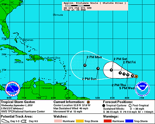
Of course, Gaston is currently far out in the Atlantic and its path could change, Snell stressed. However, Gaston should reach the region by Tuesday or next Wednesday as a hurricane. The category remains to be seen, but Snell said while some models have it as a Category 1, others put it as a Category 2 or Category 3.
Gaston started Wednesday as Tropical Depression 9. By the 5 p.m. update, it had become Tropical Storm Gaston. Snell said Gaston is forecast to become a hurricane Sunday.
As of 5 p.m. Wednesday, Gaston is centered at 12.9 degrees north latitude and 37 degrees west longitude. Currently, tropical storm force winds extend outward 70 miles. It now sits 1,635 miles east of the Leeward Islands.
The wind speed stands at 40 mph with higher gusts. It is moving west at 15 miles per hour. The barometric pressure stands at 1005 millibars or 29.68 inches.
As for Fiona, at 5 p.m. the storm was passing 185 miles northeast of St. Thomas. As Snell discussed Fiona’s track, the skies in Coral Bay, St. John clouded and rain began to fall.
“I doubt you will get any wind,” Snell said.
Tropical storm-force winds extend outward 140 miles from the center.
As of 5 p.m. Wednesday, Fiona is centered at 20.2 degrees north latitude and 62.9 degrees west longitude.
The wind speed stands at 60 mph with higher gusts. It is moving northwest at 20 mph. The barometric pressure stands at 997 millibars or 29.44 inches.